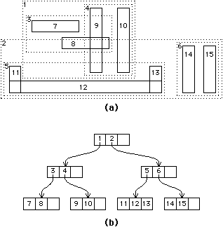
R-trees , are a variant of B-trees which are extremely efficient , for spatial databases , as their structure and oraganisation , greatly has a lot of implied order and spatial relations.
R-trees , are also called as MBR trees( Minimum Bounded Rectangle ) . Their way of indexing and searching mechanisms , greatly resemble with that of B-Trees , wherein , we start at the root node and proceed to the leaf node , which contains the actual node information. In R-Trees , the search begins , at the periphery of the outermost rectangle. The search proceeds to the rectangle , which bounds the rectangle , to be searched at the next level , until the rectangle is actually found.
Insertion , always occurs at the node , which has the least number of nodes. If their exists a conflict , the node is added at the node , which contains the minimum area .
IBM ' s Informix database , uses R-tree in it's indexing mechanism.
For a complete overview,
Visit : http://en.wikipedia.org/wiki/R-tree
For a simple demonstration,
Visit: http://gis.umb.no/gis/applets/rtree2/jdk1.1/
Posted By,
Jayanthi GM (Course Instructor Java , PESIT)
Prashanth Raghu ( Student Assistant)
Subscribe to:
Post Comments (Atom)

No comments:
Post a Comment